Land Survey in Rockville, Maryland
Rockville, Maryland—now a bustling suburb of Washington, D.C.—has a rich history of land surveying that reflects broader patterns of settlement, land use, and urban development in the Mid-Atlantic region.
From its colonial roots to its present-day role as a governmental and residential hub in Montgomery County, the evolution of land surveying in Rockville tells a story of growth, innovation, and community planning.
The foundations of land surveying in Rockville date back to the 18th century, when European settlers began moving inland from the Chesapeake Bay and Potomac River regions.
The land that would become Rockville was originally part of a larger tract known as “Hungerford’s Tavern,” named for a central tavern that served as a meeting place.
Surveyors of the time used rudimentary tools such as Gunter’s chains, compasses, and early versions of the theodolite to divide large tracts into parcels for farming, trade, and residential use.
These surveys were essential for establishing land ownership under colonial land grants, many of which were issued by the Lord Proprietor of Maryland.
Land Survey in Rockville, Maryland 1776
In 1776, the Maryland General Assembly formed Montgomery County, and what is now Rockville became the county seat.
As part of the administrative process, new surveys were commissioned to define town boundaries, roads, and land parcels.
This era saw a more organized and methodical approach to surveying, with detailed plats (maps) filed at the county courthouse—many of which are still archived today in Montgomery County’s land records.
The 19th century brought the arrival of the railroad, specifically the Metropolitan Branch of the Baltimore & Ohio Railroad in the 1870s, which transformed Rockville from a rural crossroads to a more connected, economically vibrant community.
Surveyors played a key role in plotting the railroad’s path and mapping new neighborhoods that developed around the train stations.
The use of more precise instruments like transits and steel measuring tapes improved accuracy and allowed for more complex land division and infrastructure planning.
In the 20th century, Rockville experienced rapid suburbanization, especially after World War II.
With the rise of subdivisions, shopping centers, and government buildings, surveying took on new importance.
 Montgomery County implemented zoning regulations and land-use codes, requiring modern surveys for all development projects.
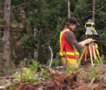
Surveyors began to rely on aerial photography and, later, satellite-based GPS technology to map land with unprecedented accuracy.
Today, land surveying in Rockville is a highly technical field, combining traditional skills with advanced geospatial tools.
Surveyors work closely with developers, engineers, and government agencies to support infrastructure projects, environmental management, and property transactions.
Rockville’s planning and permitting processes rely heavily on accurate surveys to ensure compliance with modern standards and to preserve the historical integrity of older districts.
From colonial boundaries to contemporary GIS mapping, land surveying has shaped Rockville’s landscape for over 250 years. It remains a vital profession, connecting the city’s past to its future through careful measurement and thoughtful land stewardship.
Here are several reputable sources that provide historical context and details on land surveying in Rockville, Maryland:
- City of Rockville – History Overview
This official city page outlines Rockville’s development from its indigenous roots through colonial settlement and its designation as the Montgomery County seat in 1776. It highlights the town’s early names—such as Owen’s Ordinary and Hungerford’s Tavern—and the role of landowners and surveyors in shaping its layout. - Haller & Blanchard – Maryland Land Survey History
This article provides a comprehensive look at the evolution of land surveying in Maryland, starting from the 17th century. It discusses the 1723 “Act for the Better Ascertaining of the Bounds of Lands,” which standardized surveying practices, and highlights significant surveys like the Mason-Dixon Line. - Montgomery County Circuit Court – Land Records Department
For those interested in historical land records, this department offers access to subdivision plats, deeds, and other documents pertinent to Rockville’s land history. These records can provide insights into how land parcels were surveyed and recorded over time. - Montgomery History – Property Research Guide
This resource offers guidance on conducting property research in Montgomery County, including Rockville. It explains how to trace land ownership and understand historical surveying records, which can be invaluable for in-depth studies. - EYA – Rockville, Maryland: A Renaissance Story
This article discusses the transformation of Rockville from a rural outpost to a metropolitan suburb, emphasizing the role of surveyors in this evolution. It provides a narrative on how land surveying contributed to the city’s development in the 19th and 20th centuries. - Wikipedia – Rockville, Maryland
The Wikipedia page for Rockville offers a detailed history section, including information on early land patents and the town’s development. It mentions that in 1784, local landowner William Prather Williams hired a surveyor to lay out much of the town, indicating the importance of surveying in Rockville’s early growth.

Land Survey
Oldest, Most Trusted, and Most ExperiencedLand Surveyors


ALTA - NSPS Survey
Experience Counts. Rest Assured

Property Survey
Professional and AccurateProperty Surveyors


Site Survey
Avoid High Cost MistakesSite Surveyors


Done Fast, Done Right

Boundary Survey
Haller, Blanchard 37 Yrs in FrederickBoundary Surveyors
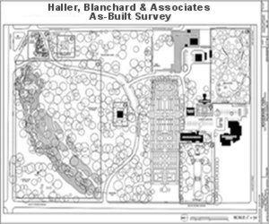
As Built Survey
More Detailed and ResearchAs-Built Surveyors

Wall Check Survey
Avoid Costly Legal Disputes
Topographic Survey
Fast Surveys and Permits Lowers CostTopographic Surveyors